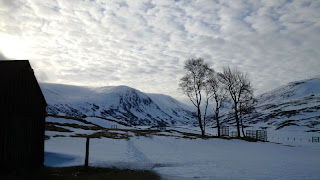
The 2nd week in April saw me make the long journey to Scotland and the Lochnagar Mountains where I would meet up with Helen, Adam & Andy who I had the good fortune to meet on the Winter Mountain Leader course at Glenmore Lodge in March.
 |
| Glen Callater |
|
|
The Lochnagar area can be found in the South-Eastern Grampians known as The Mounth and much resembles the nearby Cairngorm massif with a central plateau and Glens eroded from grey & pink granites drawing water from glaciated bowls into streams, lochan's, loch's before feeding into rivers such as the Dee, Isla & Tay.
Meeting at the Ranger Station at Glen Doll the 4 of us readied ourselves and checked our kit for the 2 day winter route and overnight stay at the Stables Mountain Bothy at Callater.
Our route took us up the flank of Corrie Kilbo on the well banked up footpath. On reaching the top of the Corrie we took a bite to eat and a drink before ditching our kit to walk to the summit of our first Munro of Driesh (947m), we then retraced our steps back to our kit before heading for our second Munroe of Mayar (928m).
 |
| The Alpine looking path to Corrie Kilbo. |
 |
| Helen steps 'up' onto the trig point! |
|
|
 |
| The plateau of Lochnagar. |
|
From Mayer we were to head to Tom Buidhe (957m) and our navigation skills were put to the test in the swirling white out conditions, as well as our resolve as the summit appeared to be moving away from us when we did get a glimpse!
White Out conditions where it is next to impossible to see the difference between the ground and sky make navigation a challenge and faith has to be put into the use of the compass to show the direction of travel and map reading skills to be able to relate to lines of contour as most land features are covered beneath the snow!
 |
| Andy climbs the summit cairn(!) of Tolmount. |
Eventually catching up with the summit of Tom Buidhe we decided to bag a fourth Munroe of the day and took a route to Tolmount (958m) before heading for 'Jocks Road', the path which would take us down into Glen Callater and onto The Stables Mountain Bothy where we aimed to spend the night.
 |
| Glen Callater |
 |
| At last the overnight bothy! |
The Stables bothy at Callater is operated and maintained by the
Mountain Bothy Association and is open 365 days a year for anyone to use free of charge. Offering some where to shelter the bothies are ideal when planning a few days out in the mountains.
 |
| The Stables Mountain Bothy, indoor camping! |
|
|
After food (including cake for Helen's birthday!) and a good nights sleep we awoke around 7am and prepared for our 2nd day and long walk back to the cars!
Deciding we wanted to make the 2days a circuit so as not to retrace our steps and to also bag a further 3 Munroe's we made our way from the bothy up the flanks of the Glen above Loch Callater and up to the summit of Carn an t-Sagairt Mor (1047) and the highest point of our route.
The weather was much clearer than the previous day and we could enjoy views out across the area, we also saw large numbers of Mountain Hare and a couple of herds of Red Deer numbering 50-100 individuals.
 |
| Clearer skies en route to Broad Cairn. |
After the steep climb of the day to the summit of Carn an t-Sagairt Mor we chose a route that would see us remain on the high ground as much as possible and allow us to bag 2 more Munroe's of Cairn Bannoch (1012m) and Broad Cairn (998m).
From our final Munroe of Broad Cairn we were treated to views into Loch Muick and out over the plateau.
 |
| Summit of Broad Cairn (998m). | | | |
|
Leaving Broad Cairn we headed down to the bridge at Bachnagairn, where we could cross the South Esk River, after a brief food stop at a sheep fold and snow filled shelter.
From the bridge we had a 5km walk along the river back to the Ranger Station at Glen Doll.
 |
| Food stop at the snow filled shelter. |
|
 |
| River South Esk. |
 |
| The final few metre's with the snow covered hills behind. |
|
Summary
In total the 2 day route was 39km in distance and we ascended just short of 1800m in height. We walked for approx 17hrs in total, and climbed 7 Munroe's.
We saw Red Deer, Mountain Hare, Ptarmigan, Black Grouse & Raven.
Quality 2 day route (though long!) with quality people!


No comments:
Post a Comment